

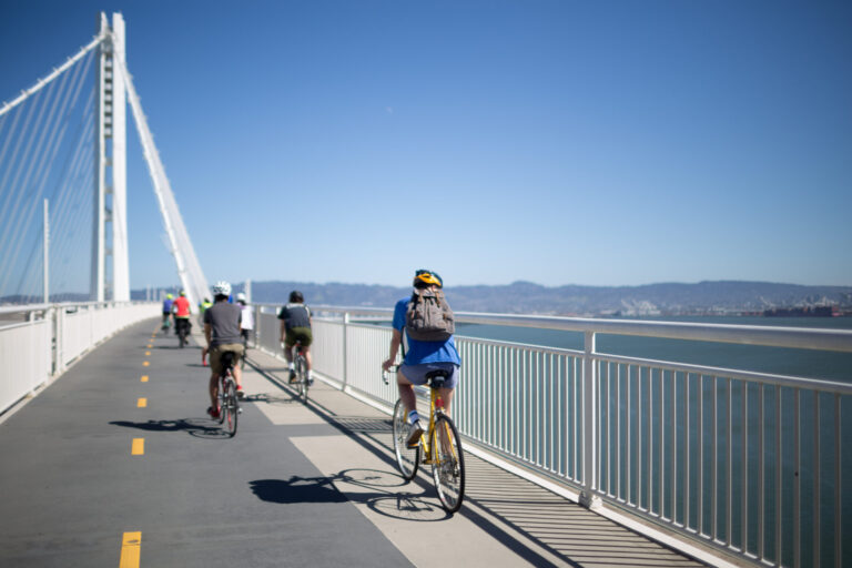
The East Span Bicycle and Pedestrian Path on the Bay Bridge named after Bike East Bay founder Alexander Zuckerman, a tireless advocate, celebrates its 13th anniversary on September 3, 2026. The views from the path are gorgeous! But it’s not as nice for many.
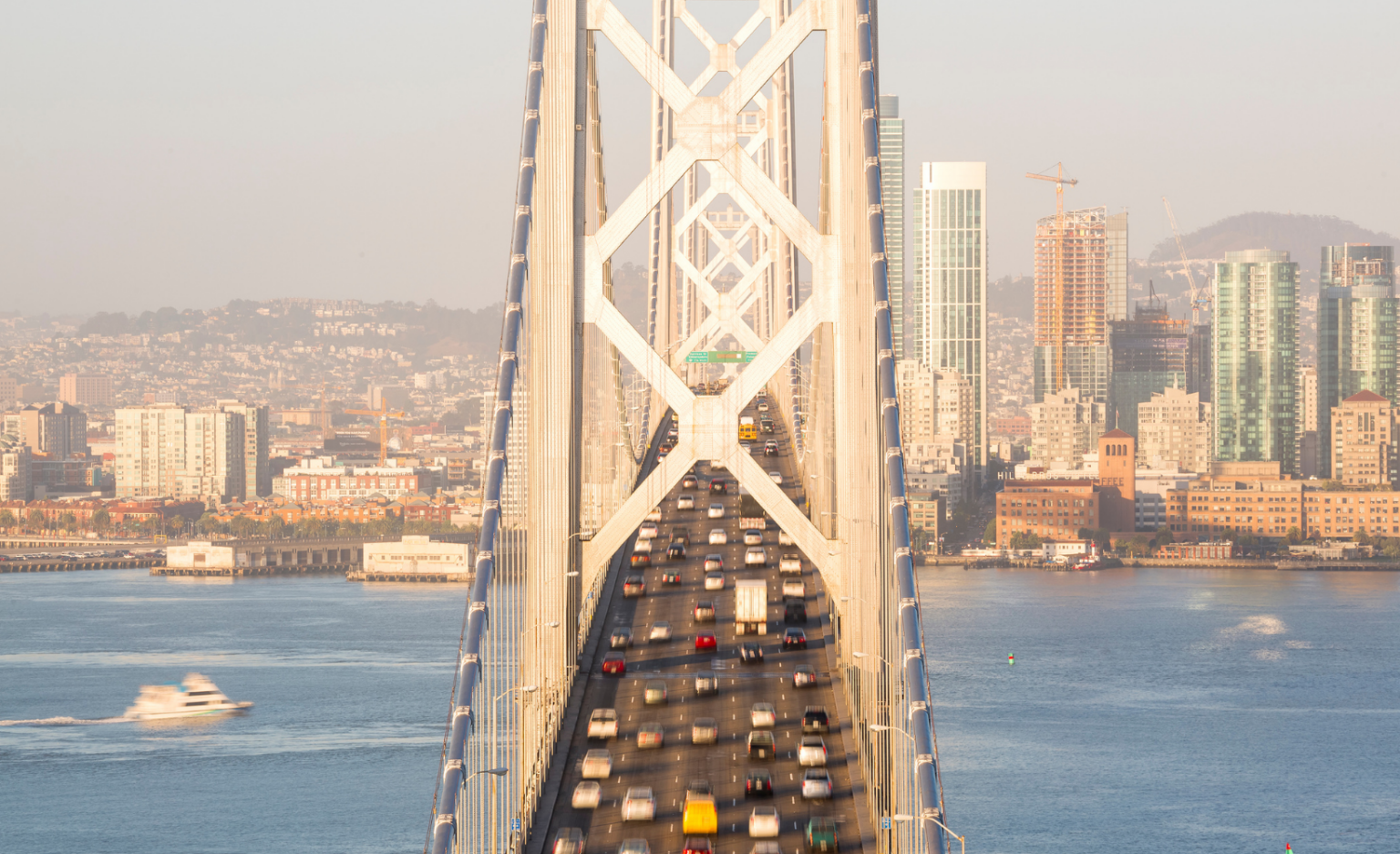
Every morning, tens of thousands of East Bay neighbors sit in the same lines, inching toward San Francisco. The Bay Bridge is the region’s workhorse, carrying one-third of all traffic on Bay Area state owned toll bridges — averaging nearly 43 million one-way trips per year.
But according to a recent study by TomTom, the situation is reaching a breaking point.
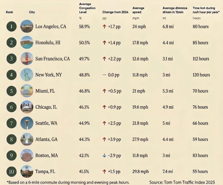
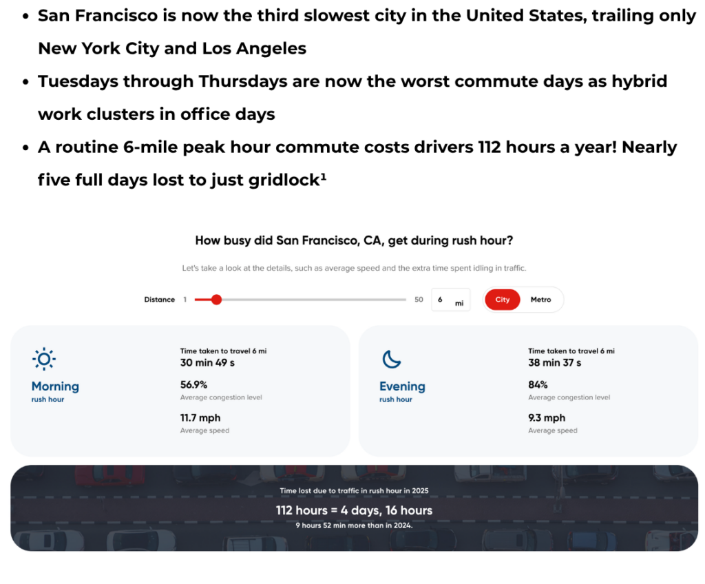
The solution is not (and has not been) more car lanes
Induced demand (or induced traffic) is a well known and studied phenomenon in transportation planning. It encourages more driving and the benefits, if any, of the additional capacity, vanish within 5 years. What actually works is giving people a genuine choice.
The path that stops in the middle of the Bay
Many of us know about the bike/walk path….but we often hear from folks who don’t walk or bike as much and have never heard of it! Since opening in 2013, it has served over 914,000 trips, running from the Oakland waterfront all the way to Yerba Buena Island.
And then it stops.
There is no direct bike route from Yerba Buena Island to downtown San Francisco. People on foot or bikes are left with less desirable options:
- The Bay Bridge bike shuttle that runs during peak commute periods between MacArthur BART Station and Main Street in San Francisco.
- BART is the East Bay’s backbone, but it doesn’t serve many who are further away from stations, those for whom the price tag is high, and those who don’t feel safe in their system.
- An infrequent ferry system with gaps on the schedule, premium costs, cargo bike restrictions and first-last mile issues.
- A bus with long wait times that also gets stuck in traffic despite HOV lanes and a dedicated lane on the bridge approach. First-last mile issues that result in multiple transfers.
- Or a 40-mile detour via Marin, only made harder by Caltrans’ decision to close the Richmond-San Rafael Bridge trail Mondays through mid-Wednesdays.
This missing western span connection is the single biggest barrier to making bicycle commuting to downtown San Francisco a real option for East Bay residents.
The Vision: The Bay Skyway
The Bay Skyway, a project from the Metropolitan Transportation Commission, would create a continuous car-free route from West Oakland to the heart of San Francisco.
A completed path would advance:
- Equity: Provides an affordable option for workers who can’t afford the daily tolls and fares, in addition to workers who work outside of hours when transit is available.
- Sustainability: Helps meet our regional and statewide climate goals. This is especially important for communities such as West Oakland, which sits directly beneath the bridge approach, burdened by disproportionate amounts of air pollution that lead to negative health outcomes for families and community members, such as asthma and respiratory illness.
- Multimodal options: Reduces congestion by providing accessible options for people who want to connect across the bay in addition to the East Bay Regional trail network and the new electric transit island ferry.
- Access: Provides a connection for bicycle/e-bike/micromobility users going between San Francisco and Oakland. It also provides 20,000 future residents of Treasure Island with improved transit and bicycle access to the East Bay and regional rail such as BART, Capitol Corridor and Amtrak.
- Car-Free Housing: In the next decade, significant housing developments are planned in the areas around downtown San Francisco and adjacent to the Multimodal Bay Skyway. Projects include 8,000 units on Treasure Island, 5,000 in West Oakland and 29,000 in downtown Oakland, including thousands of affordable homes.
- The progress toward a completed Bay Trail: Without the path, there’s currently a massive gap on the planned 500-mile trail between 2 of the region’s largest cities.
Long-Term Solutions, Not Band-Aids
Some cities are actually seeing congestion improve. New York, New Orleans, Paris and Rome, saw some reductions in per-kilometer travel times last year. What do these cities have in common? They have invested in multi-pronged approaches and infrastructure that give people genuine alternatives to driving: protected bike lanes, pedestrian paths, and multimodal networks that make it easy to leave the car at home.
Completing the Bay Bridge path is not a luxury. It is a foundational piece of the sustainable transportation future that our region has promised to build, and that our climate and our commuters urgently need.
A toolkit for change
A completed bridge path is the connective tissue, but it works best when layered with proven solutions:
- More frequent and convenient BART service, with 10 minute headways.
- Expanded Bay Ferry routes
The 2050 Service Vision and Expansion Policy adopted by the San Francisco Bay Ferry Board of Directors in 2024 commits to enhance, expand and electrify regional water transit. Four new proposed services are identified as near-term Tier 1 expansion opportunities: Berkeley, Mission Bay (San Francisco), Redwood City, Treasure Island (San Francisco).
Tier 2 expansion opportunities identified for further exploration include: Carquinez Strait communities such as Martinez, Pittsburg and Antioch, Hercules, Direct East Bay-Marin County service, Foster City, additional routes serving South San Francisco, frequent service between Alameda and Oakland.
- Bus Rapid Transit on key corridors like San Pablo Ave, Fruitvale Ave, International Blvd and I-80
- Safe Routes to Transit: a network of high-quality bike lanes and paths to transit that is accessible for all ages and abilities
- Transit-Oriented Policy: Congestion pricing, dense housing near transit hubs and staggered office days to thin out peak traffic and work-from-home policies are powerful alternatives.
We know what works. We just need the political will to build it.
Add your voice! Sign the petition below
Bike East Bay has been advocating for a complete Bay Bridge path for decades.
We need to send a clear message to Caltrans, MTC, and regional leaders that East Bay residents want real alternatives, not just more lanes.
Sign our petition to demand the Metropolitan Transportation Commission to complete the Bay Bridge Bicycle Pedestrian path
A completed Bay Bridge path will give thousands of East Bay residents a genuine, affordable, zero-emission alternative to sitting in traffic every day.
The bridge is already there. Let’s finish the path now.
Sources: TomTom Traffic Index 2026 (January 21, 2026); Bike East Bay Bridging the Bay Campaign (bikeeastbay.org); Metropolitan Transportation Commission Bay Skyway Project (mtc.ca.gov)
¹ https://www.tomtom.com/traffic-index/city/san-francisco-ca/