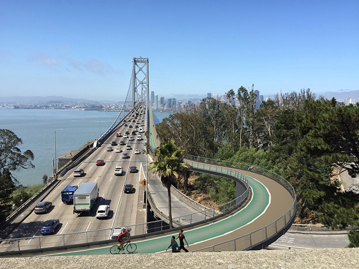
Bridging the Bay

Learn more about
this campaign

Photo of a parent bicycling on the Bay Bridge east span pathway and carrying a child in a front seat

This includes unanimous votes on resolutions to keep the trail open 24/7 from City Councils in Richmond, Albany, Berkeley, as well as via the West Contra Costa Transportation Commission and Bay Trail Board.

Over 80 transportation and sustainability organizations and community groups have signed onto Bike East Bay’s coalition letter in support of keeping the bridge trail open 24/7.

Represented in this coalition are national, state and regional organizations, as well as dozens of groups representing Richmond and other East Bay communities.

Another coalition partner is Save the Bay, one of the primary organizations that petitioned for the formation of BCDC in 1965 via the McAteer-Petris Act.

More than 5000 people have signed onto Bike East Bay’s petition in support of maintaining 24/7 biking and walking access on the Richmond-San Rafael Bridge.

The schedule as described in MTC’s proposal means there will be neither bridge trail nor shuttle access for 37 hours of every week.

This will also mean 31 hours every week when there is no trail, shuttle, or even bus access. During these hours the only way to cross the bridge will be by car.

The proposed shuttle does not appear to accommodate non-standard bike frames (recumbents, adult trikes, handcycles, etc), meaning further impacts on people with disabilities who will have no bridge crossing option. 

It’s great that MTC is continuing to explore opportunities to further enhance bike/walk access to the bridge trail, especially since some of the connectivity investments on the Marin side weren’t made until partway through or fully after the 3-year bridge trail pilot period.

However, these and all of the other investments that have been made in bridge trail connectivity will lose value if bike/walk access on the bridge is reduced.

Caltrans’ own Bay Area Bike Plan update that was just finalized this past month lists permanent, all-hours biking and walking access on the Richmond-San Rafael Bridge as one of the top ten projects for Marin County, and this is included as a Tier 1 priority project.

The permit amendment proposal Caltrans is participating in to reduce bike/walk access on the bridge is in conflict with their own, newly adopted plan.

Existing, funded projects via MTC’s Richmond-San Rafael Bridge Forward initiative to address the primary westbound congestion pinch points should be completed and studied before any further changes to the bridge are considered.

These include the open road tolling project, the westbound HOV/bus lane approaching the toll plaza, and the Richmond Parkway interchange project.

Additionally, funding for increases in transbay bus and other transit service need to be prioritized, not just transit lanes, enabling more crossings without adding more driving miles.

Join our email list for the most up-to-date info!

New Bicycle Bridges are on the way around the East Bay, to both enhance connectivity as well as reconnect communities have long been bisected by infrastructure barriers.

Campaign Map

Click the dots to learn more about each project segment

campaign events

campaign events

Join us at ribbon cuttings, rides, and trainings as part of our Bridging the Bay campaign, to celebrate these facilities and advocate for a more people-friendly East bay.

Bridges Over Waterways

Click the project titles below for info

The bridge path is at significant risk of closure all day Mondays through Thursdays, to make way for a breakdown shoulder lane! Click through to our campaign page here to learn more and speak up to help keep the pathway open 24/7.

A bicycle and pedestrian path on the Richmond-San Rafael Bridge has been in the works for decades. Throughout this project, Bike East Bay and our local partners including Rich City Rides pushed for more: We won an additional $500k for bike lane and trail improvements, plus better ferry service and new bikeways to connect Richmond neighborhoods to the bridge, the waterfront, ferry service, and one another.

The bridge path opened in 2019 after years of relentless advocacy, but it remains under attack from some who want to convert it to a car lane instead.

Thank you to those who celebrated its 4-year anniversary with us in November 2023, and at our annual group rides every November since then! The fight to keep this bridge trail open is still ongoing, so sign up for our campaign mailing list below to learn how you can help make it permanent.

The Bay Bridge is among the most well-known symbols of the Bay Area, and you can bike on it! Well… half of it.

Named after one of Bike East Bay’s founders, Alexander Zuckermann, the Bay Bridge East Span bike path is a beautiful ride, but the remainder of the trip from Treasure Island to San Francisco remains inaccessible.

Since it opened in 2013, over a million people have enjoyed walking and bicycling on the popular “people path” extending from Oakland/Emeryville.

Bike East Bay worked with Caltrans, the Metropolitan Transportation Commission (MTC), and the San Francisco County Transportation Authority to ensure completion of the bike path to Yerba Buena/Treasure Islands and safety improvements on the island.

We also are working with these agencies on designs for the Bay Bridge West Span Pathway, and building connections from West Oakland residential neighborhoods to the East Span people path.

Sign our petition here to help complete the Bay Bridge path the rest of the way to San Francisco.

Still very much in development, this proposal will span just 1000 feet between Oakland’s Jack London Square and the western end of Alameda, eliminating a 7-mile bike detour for anyone understandably deterred by the substandard 4-foot wide walkway through the noisy and dirty Posey Tube.

But it will also need to be designed to accommodate frequent Coast Guard and other boat traffic underneath, raising the cost significantly.

In the meantime a free water shuttle service started in Summer 2024 to test the demand and to raise awareness and support for the bridge project.

The water shuttle has already been a huge success, with many calling for additional service.

Bridges Over Freeways

May 2024 Update: The Berkeley Bike/Walk Bridge over 580 at Gilman St is now open! This bridge connects between a new 2-way cycletrack on the east side and the beautiful Bay Trail to the west. Take a test ride via our video preview here.

March 2024 Update: The new Mokelumne Trail Overcrossing of Hwy 4 between Brentwood and Antioch is now open! Read our blog post here about the ribbon cutting celebration, and how the bridge came to be.

Our built infrastructure creates many barriers for walking and biking, but among the most destructive are freeways that were cut through existing neighborhoods, displacing residents and bisecting communities.

Impermeable freeways also create barriers for people to access natural spaces and enjoy a major part of what makes the Bay Area so special.

In development are additional bridges over I-80 to the Bay Trail at Ashby Ave in Emeryville, the West Oakland Link bridge over 880 along W Grand Ave, and in Fremont both the Sabercat Trail bridge over 680 and the Innovation Bride over 880, all of which are in the planning stages with construction timelines dependent on funding.

Trail Bridges

July 2025 Update: The Iron Horse Trail Bridge over Bollinger Canyon Rd in San Ramon is now open! A ribbon cutting ceremony was held on July 19, 2025.

November 2024 Update: The Iron Horse Trail Bridge over Dublin Blvd in Dublin is now open! A ribbon cutting ceremony was held on November 23, 2024.

Three new bike/walk bridges along the Iron Horse Trail will take users up and over otherwise wide and imposing roadways.

These include a bridge at Dublin Boulevard in Dublin, which opened for use in November 2024, a bridge at Bollinger Canyon Road in San Ramon which opened in July 2025, and another bridge at Crow Canyon Road in San Ramon, to start construction in 2025/2026.

Another trail bridge is also in the planning stage for the Richmond Greenway crossing of 23rd Street and the Amtrak/BART tracks, closing the last gap to create a continuous trail and protected bikeway connection between central Berkeley and Point Richmond.

This bridge was the top priority identified in Richmond’s 2023 bicycle and pedestrian plan update, and will join together the two halves of the Greenway as well as the neighbors on each side.

Campaign Updates

Join our email list for the most up-to-date info!