Route Planning Tips
Planning your route in advance makes each ride less stressful, faster, and more fun! We have provided a number of resources for you to use on this page, but always recommend the following:
Try out a route in advance
Explore your route on a weekend or some other less congested time when you can relax and explore. Bring a friend and turn it into a route-scouting adventure! This will make your actual commute or other bike trip less stressful, as you will already know the way.
The best bike route is not always the most direct
While biking on any surface street is legal, you may want to try a different route than you would take if you were driving, to avoid busy streets or tricky intersections, hills, or other conditions.
Have a backup plan
Plan and know a backup route in case the one you intended to take is not available. Street conditions can change with new construction, detours, road closures, etc.
Remember: everybody bikes differently
Your idea of a great bike route might be different from someone else’s. If your ride becomes too strenuous or busy you can try another route, hop on the bus or BART, or walk your bike on the sidewalk for a few blocks until you find somewhere you are comfortable riding again.
Sharpen your bike skills
Attend a free Bike East Bay class. Our certified instructors will let you know about state and local bicycling laws, how to ride on streets with or without bike lanes, and get you some free bike lights or reflectors for participating. These classes are also a great place to meet other people interested in biking, and to share route tips.
Need route inspiration?
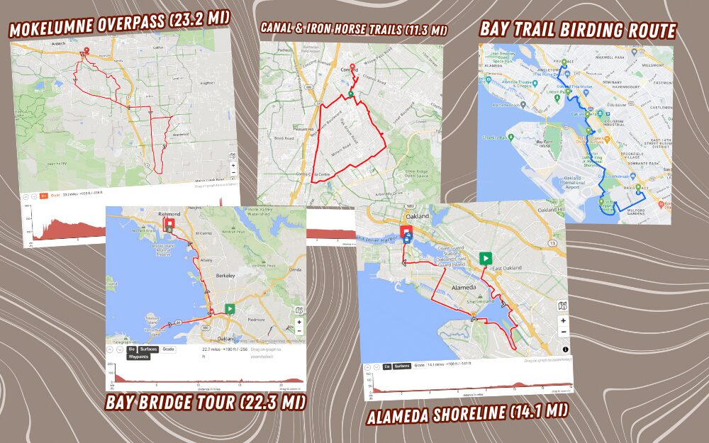
Check out our library of bike routes across the East Bay! We use Ride with GPS to plan our group rides, practice routes for our Urban Cycling classes, organize rides to Ballers games and other community events, and more!
Online Maps
Internet-based mapping resources are getting better, but are only as good as the data they rely on. It is important to always use your own judgement about whether or not you are comfortable biking on a particular street or pathway. Also, an online map isn’t very useful if you lose your cell signal or your phone battery dies, so try carrying a paper map as a backup.
- For Google Maps, if a bike route you know of doesn’t show up, you can submit feedback.
- Also, check out this handy guide to using Google Maps bike directions, from our friends at YBike in SF.
Paper Maps
Paper bike maps are great to have because they can highlight information that the online resources don’t, such as hazardous intersections, bike shop locations, hills, and other local info. Unlike a cell phone they never have to be recharged!
Bike East Bay Maps – We previously produced our own ‘West of the Hills’ and ‘East of the Hills’ bike maps of the East Bay, but these were last updated back in 2005 and are no longer in print. We recommend using the city-specific resources below as an alternative.
City-Specific Maps – Most East Bay cities are now producing their own (usually free) bicycle maps, which detail all of the official routes around town. Many of these are available both online and in paper versions:
- Alameda (updated 2022)
- Albany (updated 2017)
- Berkeley (updated 2017)
- Brentwood (updated 2019, trails only)
- Concord (updated 2016)
- Danville (updated 2019)
- Dublin (updated 2018)
- El Cerrito (updated 2012)
- Emeryville (updated 2017)
- Fremont (updated 2021)
- Hayward (updated 2020)
- Hercules (updated 2017)
- Lafayette (updated 2013)
- Livermore (updated 2018)
- Martinez (updated 2009)
- Moraga (updated 2016)
- Newark (updated 2017)
- Oakland – Including Piedmont and Emeryville (updated 2024)
- Pittsburg (updated 2019)
- Pleasant Hill (updated 2024)
- Pleasanton (updated 2019)
- Richmond (updated 2021) (trails updated 2019)
- Richmond-San Rafael Bridge trail (updated 2019)
- San Leandro (updated 2018)
- San Pablo (updated 2017)
- San Ramon (updated 2018)
- UC Berkeley (updated 2017)
- Unincorporated Alameda County (updated 2017) – Castro Valley, Ashland, Cherryland, San Lorenzo, Fairview, Sunol
- Union City (updated 2021)
- Walnut Creek (updated 2013)
If there is a city bike map missing from this list, or if any links are broken or outdated, please let us know!
Secure Bike Parking Maps – Read more about bike security at BikeEastBay.org/theft.
- BikeLink lockers and rooms (updated continuously)
- BART station secure bike parking (updated continuously)
Regional trail maps – These show mostly paved, off-street trails that run through many East Bay cities.
- San Francisco Bay Trail: Along the coastline from Martinez down to Fremont and beyond, with plans to loop around the entire Bay Area.
- East Bay Regional Parks trails: These paved, regional trails facilities connect cities around Contra Costa County, and parts of Alameda County, and are used for both recreation and transportation.