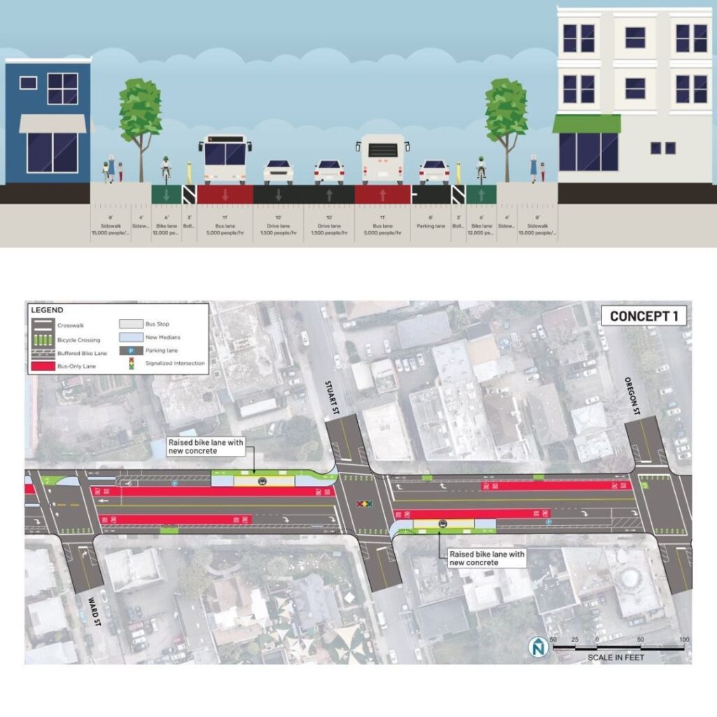
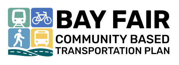
Berkeley Telegraph Ave Bikeway
The City of Berkeley would like your feedback on three concept designs for the Telegraph Multimodal Corridor Project, which stretches from Dwight Way to Woolsey Street at the Oakland border.
The project will include separated bike lanes, pedestrian safety improvements, bus boarding islands, and possibly bus-only lanes. With limited space on the street, the City needs your help deciding which features to include.
Click here to complete the survey by the July 3, 2025, deadline.
Bay Fair Community Access Needs Survey
Do you live, work, or travel in the Bay Fair BART Station area? We want to hear from you! Take a short online survey to share your experience and ideas here. Available in English, Español, and 中文 Includes a chance to win a gift card.
Your feedback will help improve walking, biking, transit, and traffic safety in the area. The survey area includes neighborhoods in San Leandro and unincorporated Alameda County around Bay Fair BART. This survey will close on 9/15/2025.
East Bay Regional Parks – The District Plan
The East Bay Regional Park District (EBRPD) is seeking community input to develop EBRPD’s next District Plan. Now is a great time to join the conversation and share your thoughts on the future of the Park District.
Please take a few minutes now to learn more and take the survey here.
Calm East Oakland Streets project
The Calm East Oakland Streets project aims to stop aggressive driving, fix broken streets, and create safe space for people to walk and bike to local destinations.
We want your feedback to ensure this project works for the community. This survey should take less than 5 minutes.
Learn more about the project here and take the survey here

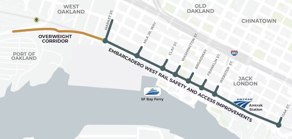
Embarcadero West Rail Safety and Access Improvements
Oakland’s Department of Transportation is collecting feedback and comments on concept designs for Embarcadero West through Summer 2024. Click here for the project survey.
The Embarcadero West Rail Safety and Access Improvements intends to improve safety, access to the waterfront, and train reliability for people and goods movement. It will intends to transform Embarcadero West into a more welcoming and connected corridor that’s reflective of the surrounding community.
Check out the Community Design Workshop Posters and video visualizations at the link below.
Complete project info is available on the Oakland city website here.
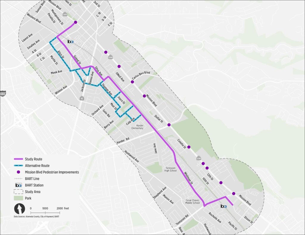
HAYWARD EAST BAY GREENWAY PLAN
The East Bay Greenway is a planned, 30-mile facility connecting from Oakland to Fremont, linking between BART stations with a series of safe bikeways for users of all ages and abilities.
The project manager Alameda CTC is asking for input on the alignment through Hayward, which unfortunately has been moved away from Mission Blvd and onto side streets. This reduces the opportunity via this project to address long-standing and serious safety and access issues on Mission Blvd itself.
We encourage you to complete the survey about the side streets alignment, comment that continuous and physically separated bikeways are needed throughout the East Bay Greenway, and comment that the Mission Blvd alignment needs to be revisitied.
Click below to complete the survey (responses due by May 31, 2024)
- English language survey
- Chinese language survey
- Spanish language survey
- Tagalog language survey
- Vietnamese language survey
You can also add your comments to the online map here: https://maps.kittelson.com/EBGWMMHayward
Project page: https://www.alamedactc.org/programs-projects/bicycle-and-pedestrian/eastbaygreenway