Loading Events

Adeline Quick Build Community Meeting – Berkeley

January 21 @ 6:00 pm - 7:30 pm
A map titled "Adeline Quick Build Project Area Map" showing a corridor plan in the City of Berkeley. The map highlights four distinct sections of the Adeline Street and Shattuck Avenue corridor, color-coded and labeled from north to south: South Shattuck (Blue): Spans from Dwight Way to Russell Street. North Adeline (Green): Spans from Derby Street to Essex Street. Ashby BART (Yellow): Spans from Ashby Avenue to Woolsey Street, centering on the Ashby BART station area. South Adeline (Orange): Spans from Woolsey Street to 62nd Street at the city border. A bold black outline labeled "PROJECT AREA" specifically encompasses the southern three sections—North Adeline, Ashby BART, and South Adeline—stretching from approximately Derby Street down to the Berkeley-Oakland border at 62nd Street. The map includes street names, city border indicators, and a legend for the City of Berkeley Adeline Corridor Plan.

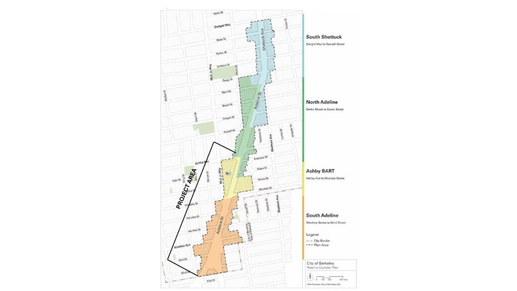
Join the online community meeting where City staff will share information about the upcoming Adeline Quick Build Project, which will extend safety improvements southward from Ashby Ave to the Oakland border. This pilot project will use temporary materials to test improvements such as bus boarding islands, pedestrian refuge islands, new/upgraded bike lanes, and fewer traffic lanes.

When: Wednesday, January 21 2026 6-7:30 PM

Where: Online via Zoom. RSVP here

Check the project website for more details.

This is not a Bike East Bay event, for questions and comments please contact the organizers.

Details
Date:
January 21
Time:
6:00 pm - 7:30 pm PST
Cost:
Event Category:
Website:
Location
Organizer