Kains and Adams Bikeway Pilot Project Survey, Albany
City of Albany staff are preparing an evaluation of the Kains & Adams Bikeway pilot project, installed last year to provide a safer north-south route parallel to San Pablo Avenue and improve cycling access to destinations along San Pablo Avenue.
Click here and fill out the feedback survey to share your thoughts (responses due by April 25, 2024)
More information can be found on the project website here.
Oakland Community-Driven Traffic Safety Program Survey
Oakland Councilmember Carroll Fife has introduced legislation to establish a pilot program allowing schools, businesses, and community centers to apply for and build their own temporary traffic safety treatments on public streets and sidewalks.
Complete this survey to weigh in on the proposed legislation.
Click here to complete the survey (responses due by May 1, 2024)
EL CERRITO ROAD SAFETY QUESTIONNAIRE
The city of El Cerrito is developing a Local Road Safety Plan (LRSP) which will be informed by survey results. The goal of the Local Road Safety Plan is to:
- Increase awareness of road safety and risks
- Reduce fatal and severe injury crashes
- Prioritize safety investments
You can learn more and take the survey on their website
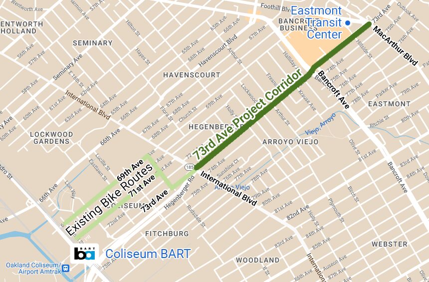
Oakland 73rd Ave Bikeway
Oakland is planning safety upgrades on 73rd Ave, and wants public input to help inform an upcoming grant application.
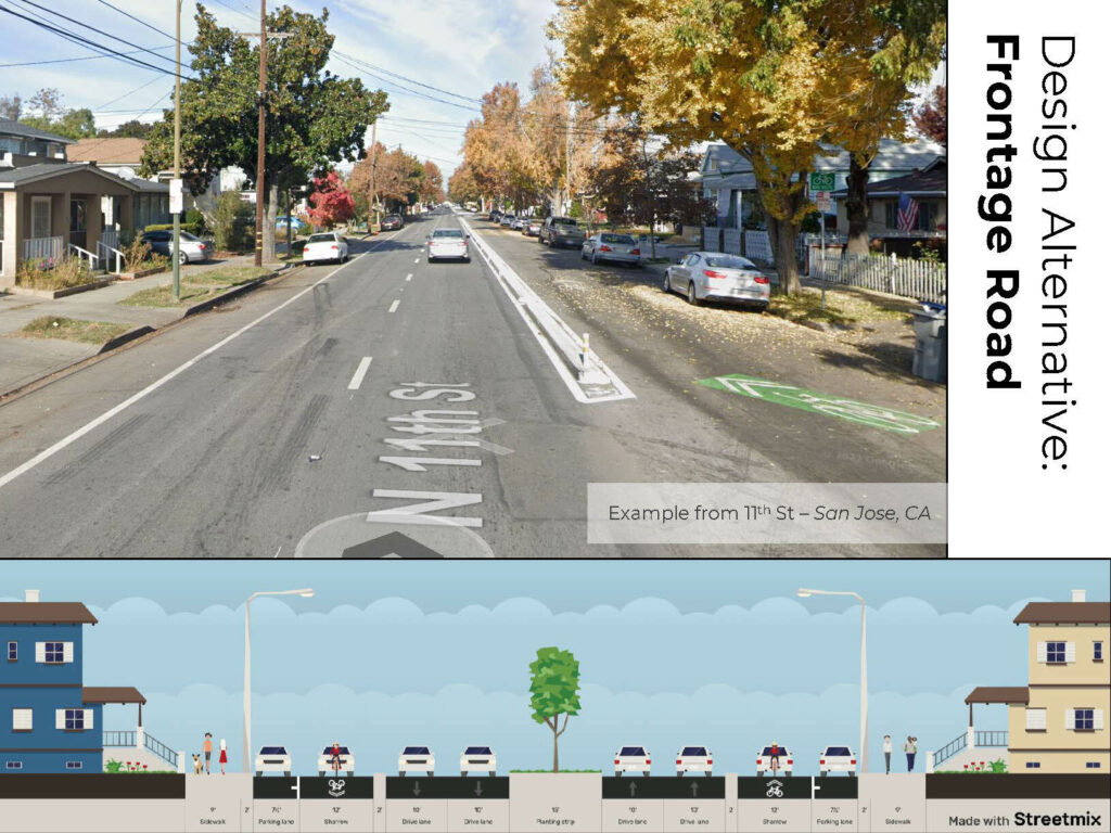
Three options are offered including a standard bike lane with a painted buffer, a median pathway, or a new type of facility they’re calling the “frontage road” alternative.
The frontage road uses a concrete curb to separate the rightmost lane from the rest of the roadway, with speed humps in that lane and protected intersections at the major crossings.
This is sort of like a combination between a bike boulevard and a protected bikeway, and follows an example installed on 11th St in San Jose. Of the three options this one is our favorite and we encourage you to support it.
Click here to complete the survey (responses due by April 1, 2024)
Click here for the 73rd Ave project page
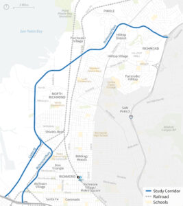
RICHMOND PARKWAY TRANSPORTATION PLAN
Phase 2 Engagement: Draft Strategy Feedback
Richmond Parkway is a freeway-like road that runs north-south through Richmond cutting off access to the shoreline and between neighborhoods, as well as the Bay Trail and Wildcat Creek Trail.
Via this survey respondents can rank the strategies they think are the highest priority to equitably expand transportation options, support safe travel, and reduce public health impacts of truck and vehicle traffic along Richmond Parkway and Castro Street between I-80 and I-580.
Click here to complete the survey (responses due by April 28, 2024)
Click here for the Richmond Parkway project page
IN-PERSON INPUT OPPORTUNITIES
- North Richmond Flea Market:
Sunday March 24, 2024
11:00am-2:00pm
716 W Gertrude Avenue, North Richmond - North Richmond Earth Day Festival:
Saturday April 20, 2024
9:00am-12:00 noon
Shields-Reid Park, 1410 Kelsey St, North Richmond
San Leandro Bicycle and Pedestrian Master Plan Update
The Bicycle and Pedestrian Master Plan is an update to the 2018 Plan that guides development of infrastructure projects and programs to support bicycling and walking as a safe, enjoyable, and practical transportation for San Leandro. As part of the planning process, the City of San Leandro is asking for your feedback to better understand your experience biking or walking in the city.
Add your comments in the interactive map available on the project page below to inform the recommendations in the San Leandro Bicycle and Pedestrian Master Plan.
Project page: https://fp.mysocialpinpoint.com/san-leandro-bpmp-1
![]()
FREMONT ACTIVE TRANSPORTATION PLAN
Fremont has embarked on an Active Transportation Plan update, looking at how to improve biking and walking all around the city. This is plan process is continuing through Summer 2024, so sign up for the notification list to also receive updates as they are posted.
Project page: https://www.my.fremont.gov/active-transportation-plan
Caltrans Bay Area Bicycle Plan Update
Freeway interchanges and state-owned surface streets (like parts of San Pablo Ave, Mission Blvd, International Blvd, Ashby Ave, and others) are among the most dangerous places for biking in the East Bay. Help Caltrans prioritize improvements via their bike plan update by adding comments to this map, and favoriting other people’s comments.
Comment map & survey: https://experience.arcgis.com/experience/cf99ad51e5404c548b2cdbd635a44f5c/
(Tip: Open this page in a private browser window to see all the comments made on the map so far, not only the ones in your vicinity)
PINOLE ACTIVE TRANSPORTATION PLAN
The Pinole Active Transportation Plan (ATP) aims to create a comprehensive vision for enhancing pedestrian and cycling experiences in Pinole, catering to individuals of diverse ages and abilities with the goal of decreasing Vehicle Miles Traveled (VMTs).
Click through to learn more, add your comments via the web map and survey, and find dates for in-person pop-up events around Pinole.
Interactive web map: https://ghd.mysocialpinpoint.com/pinole_atp/map#/
Project page: www.WalkAndRollPinole.com
![]()
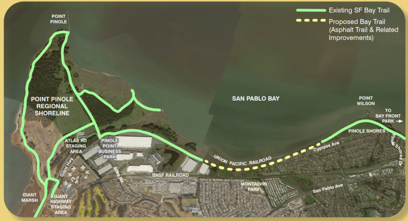
Point Pinole to Point Wilson Bay Trail gap closure
This proposed one-mile Bay Trail gap closure, in conjunction with another Bay Trail project in the works on San Pablo Ave from Rodeo to Crockett, will create a continuous bikeway all the way between Richmond and the Vallejo via the Carquinez Bridge.
Complete this survey to let the East Bay Regional Parks District know what you would like to see included in the project.
Survey link: https://www.surveymonkey.com/r/PPKKX6F
Project page: https://www.ebparks.org/projects/san-francisco-bay-trail-point-pinole-wilson-point
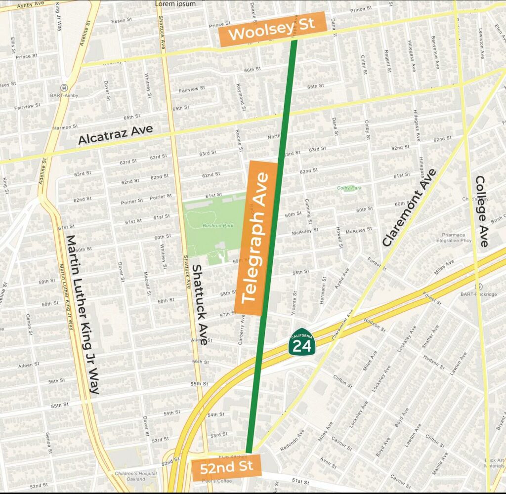
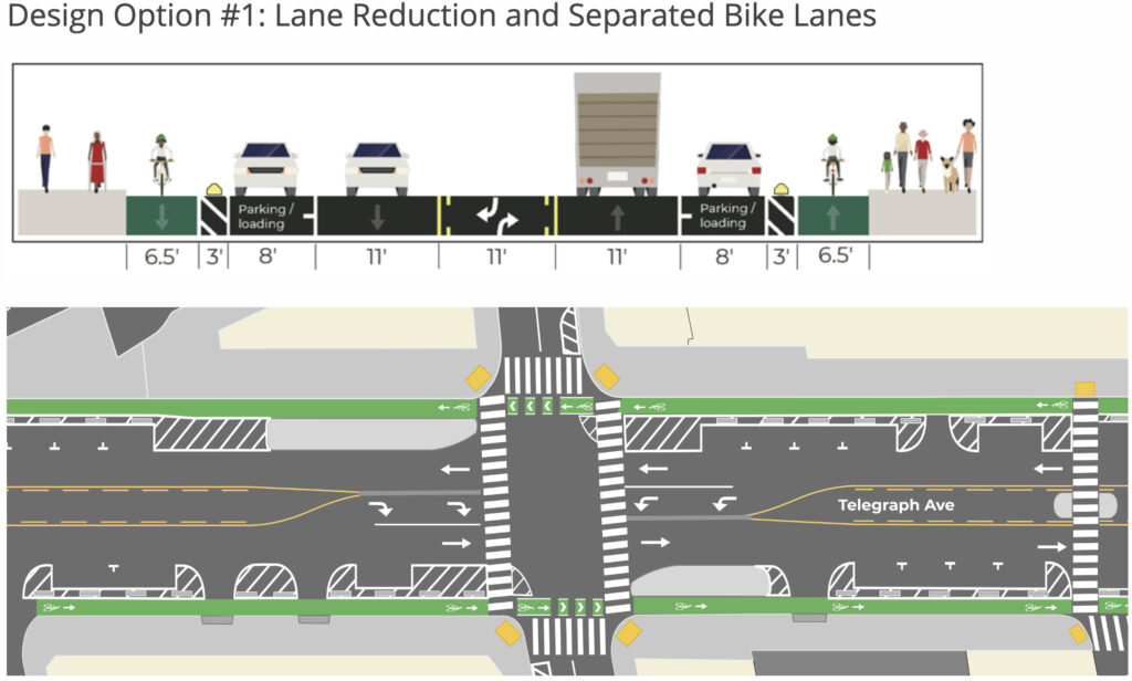
UPPER, UPPER TELEGRAPH AVE PROTECTED BIKEWAY, OAKLAND
Telegraph Ave from 52nd St to Woolsey St will be repaved as part of Oakland’s Five-year Paving Plan. This paving work presents an opportunity for the City to integrate design elements that will enhance connectivity and safety for pedestrians, bicyclists, and transit riders.
Planned Improvements Include:
- Separated bike lanes
- Upgraded and new curb ramps
- High-visibility crosswalks
- Bus boarding islands
Potential Improvements Include:
- Bus-only lanes
- Flashing lights at crosswalks
- Pedestrian refuge islands
- And more
Click here to complete the survey (responses due by January 31, 2024)
January 17, 2024 open house meeting info here
San Pablo Dam Rd Bike Lanes, El Sobrante
The Contra Costa County Public Works Department is soliciting feedback on the installation of a road diet along San Pablo Dam Road in El Sobrante. This would convert the four-lane road to a three-lane road with a center lane. The road diet will also provide additional width for bicycle lanes in both directions.
If this project receives sufficient community support and is supported by the Board of Supervisors, the County will then pursue grant funding opportunities to construct the road diet in the near future.
Click here to complete the survey (responses due by January 26, 2024)
We encourage you to select the Alternative A extending to Appian Way as your choice. This will connect to an existing bike lane on Appian and provide safety upgrades from May to Appian, which has an above average crash rate.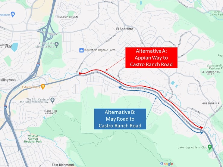
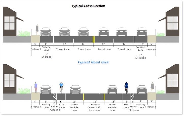
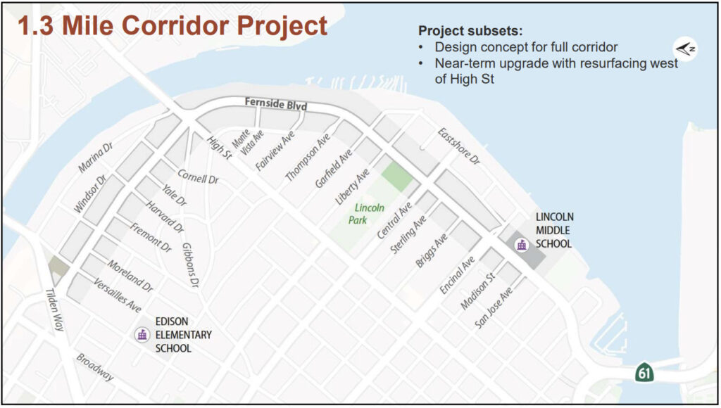
Fernside Blvd Traffic Calming and Bikeways, Alameda
This project will create a design concept to update Fernside Blvd from Tilden Way to San Jose Ave, aiming to reduce car speeds and increase safety and mobility for all road users, as well as develop design concepts to implement Active Transportation Plan bikeways.
It will also work to develop a near-term striping update for Fernside from Tilden Way to High St that can be implemented with pavement resurfacing.
Click here to complete the survey (responses due by December 17, 2023)
Link 21 Open House
Link21 is a passenger rail Program that aims to improve train travel and connect the rail networks in Northern California.
The centerpiece of the Program is a second train crossing between San Francisco and Oakland as envisioned in the California State Rail Plan.
Along with the new crossing to accommodate travel within the congested Transbay corridor, Link21 includes improvements to both San Francisco Bay Area Rapid Transit District (BART) and Regional Rail networks.
Link21’s Online Open House is live until Dec. 15th!
The Open House includes more information about the Program, the upcoming decision between BART and Regional Rail in a new transbay crossing, and a short survey where you can provide feedback.
Project page: https://www.link21openhouse.com/
![]()
DOWNTOWN OAKLAND BROADWAY STREETSCAPE
Provide input on a proposal for transit upgrades along Broadway from Jack London Square through Downtown, as well as opportunities for bike and pedestrian improvements. This short survey is available in English, Chinese, and Spanish.
Survey link: https://us.openforms.com/Form/5e50d690-184a-44d0-a771-a0bc736ca6f2
Project page: https://www.oaklandca.gov/projects/broadway-streetscape-improvements
DOWNTOWN OAKLAND MLK JR WAY STREETSCAPE
Weigh in on this proposal for protected bikeway and pedestrian upgrades along MLK Jr Way from 2nd Street to 14th Street, along with new street trees and paving. This short survey is available in English, Chinese, and Spanish.
Survey link: https://us.openforms.com/Form/49e883fb-da1d-4170-b989-f1bc7d764f91
Project page: https://www.oaklandca.gov/projects/martin-luther-king-jr-way-streetscape-improvements
OAKLAND CHINATOWN COMPLETE STREETS PLAN
The City of Oakland and local community partners are investigating what improvements are needed on these important streets in Chinatown: 10th Street, 7th Street, the 8th & 9th Streets pair, and the Webster & Harrison Streets pair. Take the survey below and register for updates on the project page.
Survey link: https://docs.google.com/forms/d/e/1FAIpQLSdTN6QTNi8Nk55-4MX1tMOgspA54LSNtd-nFNvp0itivZqg7Q/viewform
Project page: https://www.oaklandca.gov/projects/chinatown-complete-streets-plan
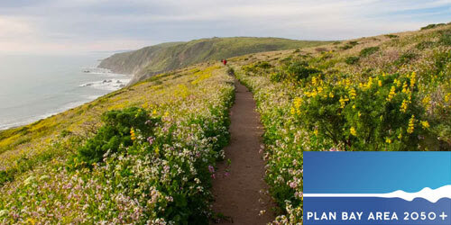
PLAN BAY AREA 2050+
Provide your input on how life in the Bay Area has changed as the region emerges from the pandemic. This effort is an update to Plan Bay Area 2050, the Metropolitan Transportation Commission’s adopted long-range regional plan for the 9-county Bay Area to shape decisions and priorities on transportation, housing, land use, and the environment.
Survey link: https://www.surveymonkey.com/r/MTC-ABAG
Project page: https://www.planbayarea.org/plan-bay-area-2050-plus
RICHMOND PARKWAY TRANSPORTATION PLAN
Place pins on the map where you would like to see biking and walking improvements along the Richmond Parkway, a freeway-like road that runs north-south through Richmond cutting off access to the shoreline and between neighborhoods, as well as the Bay Trail and Wildcat Creek Trail.
Survey link: https://www.wcctac.org/app_pages/view/1182
Project page: https://fp.mysocialpinpoint.com/richmond-parkway
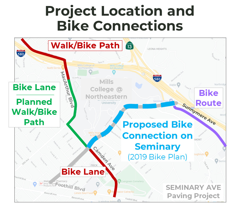
OAKLAND SEMINARY AVE PAVING & BIKEWAY PROJECT
Oakland DOT is requesting input on a proposal for bikeway upgrades along Seminary Ave from MacArthur Blvd to Sunnymere Ave, alongside planned repaving in 2025. This short survey is available in English, Chinese, and Spanish.
Survey link: https://us.openforms.com/Form/37cbadb7-fafc-49ca-8649-a88761d81a5b
Project page: https://www.oaklandca.gov/projects/seminary-ave-paving
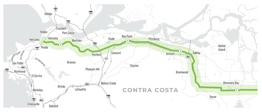
CONTRA COSTA STATE ROUTE 4 CORRIDOR VISION STUDY
Help plan a more bike, walk, and transit-friendly future for State Route 4, which runs east-west across Contra Costa County from Hercules to Brentwood and beyond. Visit the CCTA website below and fill out the survey to let them know that non-car mobility and safety needs are a priority! Then scroll to the bottom of the page to sign up for updates and stay engaged.
Project page and survey: http://ccta.net/planning/sr-4-vision-study/
NEWARK ACTIVE TRANSPORTATION PLAN
Help Improve Walking and Biking in Newark! The Newark Active Transportation Plan is an opportunity to advance infrastructure that supports walking, biking, and rolling throughout the City. Comments on current challenges and safety concerns are welcome on the interactive webmap through September 15, 2023. Visit the project website to learn more.
Webmap link: https://fp.mysocialpinpoint.com/newark-atp
Project page: https://www.newark.org/departments/public-works/engineering-division/active-transportation-plan